Collection by Diana Budds

A Five-Act History of Urbanism in Barcelona
Labyrinthine alleys, majestic avenues, meandering parks, and pristine beaches—this is the urban fabric of modern Barcelona, a city 2,500 years in the making. We've traipsed the Catalonian capital's streets this past week and to provide orientation and context to the photos shared via our Instagram feed, here's a brief history of the city divided into five acts.
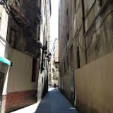
The oldest part of the Barcelona is known as the "Ciutat Vella," (shown here) and is divided into smaller neighborhoods. Though it's still characterized by tiny, winding streets from centuries ago, it's seen its share of changes. A few wider boulevards built in the 20th century bifurcate the old plan and in the late 1920s, the government tasked architect Adolf Florensa with restoring and reconstructing the Medieval core for the 1929 World's Fair.
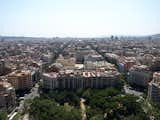
Act 2: ExtensionIn 1800s, the compact city was busting at its seams with hundreds of thousands of residents packed into the old city at an overall density of 856 inhabitants per hectare—that's the equivalent of 220,000 people per square mile. (In comparison, Manhattan's current density is 66,940 people per square mile.) Living conditions were crowded and dimly-lit. Poor sanitation resulted in epidemics. In 1854, Queen Isabella II decreed that the old walls be torn down to allow for rapid expansion.
Here's a present-day view of the area. Photo via Flickr by Roberta R.
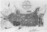
Civil engineer Ildefons Cerda designed a plan for the "Eixample," Catalan for "extension." The government approved his scheme, shown here, in 1856. Cerda dictated a regular street grid with city blocks measuring 371 feet by 371 feet, buildings with a depth of no more than 78 feet on each side, a central green space within each block, and streets measuring 65 to 98 feet wide—the optimum dimensions to ensure a good quality of life—maximum daylight, strong air circulation, ample living space. One of Barcelona's most-unique urban elements is the octagonal street intersection and city block shape. Cerdas did that to make it easier to turn corners and to provide more public space on the sidewalks. His design was so forward-thinking it remained in place as the city's official plan until 1953.
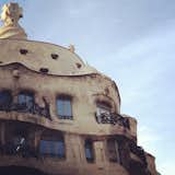
Casa Mila, architect Antoni Gaudi's residnetial project completed in 1912, is located in the Eixample.
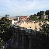
Act 3: ParksOne of the city's—and the world's—most lauded public spaces is the Park Güell. Though the street network of modern Barcelona is very regimented and regular, Gaudi's plan for the 42-acre park is modeled after British landscapes, which favors snaking pathways, unmanicured plantings, and an irregular design that mimics what nature might do if left untouched. It's located in the hilly western section of the Barcelona. Wealthy landowner Eusebi Güell commissioned the plan, which was to include housing for wealthy denizens of the city and was modeled after Ebeneezer Howard's Garden City movement.
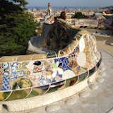
Construction began in 1900 and continued until 1914 when the outbreak of WWI stalled further construction. Josep Maria Jujol, Gaudi's collaborator, executed the elaborate mosaics adorning many of the park's surfaces. View a Vine video panorama of Gaudi's famous serpentine seating area here.
Act 4: TransportationBarcelona built its first Metro line in 1924. It's since grown to encompass 11 lines with 166 stations and 80 miles of track.
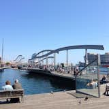
Act 5: Waterfront RehabilitationThe 1992 Olympics spurred the most-recent changes to the overall urban fabric, namely ring roads around the city and the revitalized waterfront. Prior to then-mayor Pasqual Maragall's plan, the coastline was mostly heavy industry—polluted and cut off from pedestrians. Maragall moved part of a highway underground, making the waterfront easier to access by pedestrians. He also built promenades—like the one in Port Vell, shown here—and sandy beaches, which continue to attract loads of visitors.
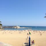
Here's one of the city's popular beaches.
For more stories on how cities came to be, visit "10 Diagrams that Changed City Planning" and "A Brief History of the Birth of Urban Planning."